
|
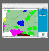
The Transport Assessor
is a web-based system designed to make transport information more
widely available. It is based around MapInfo’s MapXtreme web-enable
GIS software, but has web pages that are concerned with assisting
the user in selecting the information that is suited to their interests
and perspectives. This means that the system is designed for people
who may have a professional interest as technical specialist or
senior decision makers, as well as those who have an occasional
interest, whether as a specialist in a non-transport area or simply
as a member of the public with no special knowledge of the topic
A common thread exploited by the Transport Assessor
is the ease by which transport-related information can be presented
and comprehended in map form, but it also brings information together
by allowing it to be accessed via a ‘time line’ that
make clear how the information might related to past monitoring
information or future forecasts. Standard web facilities are available
for retrieving information via hyperlinks
The Transport Assessor contains communication facilities,
in the form of a bulletin board, designed to encourage contact between
people with similar interests, for example, in school travel matters.
It also has security facilities designed to encourage people to
include informal information that can be shared with others who
may be expected to understand the context and any limitations of
the information
The Transport Assessor is not packaged software,
but is a set of components that may readily be customised to meet
the specific needs and interests of individual clients.
Further information
is available in a note (PDF format) that can be downloaded.
(Contact:
Miles Logie)
|
|
 |
